Issue 51
This is a long release because it’s been a few weeks.
All issues can be found at: https://geocraic.com/
Please do let me know if you’re hitting paywalls with the links. I try to avoid this or at least notify when there is one.
Subscribe here: https://geocraic.com/pages/discussions.html
World
The most dangerous sea route in the world. The video is highlighted for it’s design by design illuminati Edward Tufte himself. The YouTube channel has more interesting content as well.
- From GeoGlobeTales: https://www.youtube.com/shorts/dXf2N63I2pg
- Tufte’s comment on Twitter:
“Beautiful explanation of centuries-long huge historical consequences of gravity and fluid dynamics. Amazing invisible design entirely about substantive content. And is that invisibility is what excellent design is all about.”
- Beautiful design is always worth the effort. Or, be like me. I mostly suck at it so I get help from my friends who are great at it. The point is to put the time into it.
World Capitals and Elevation
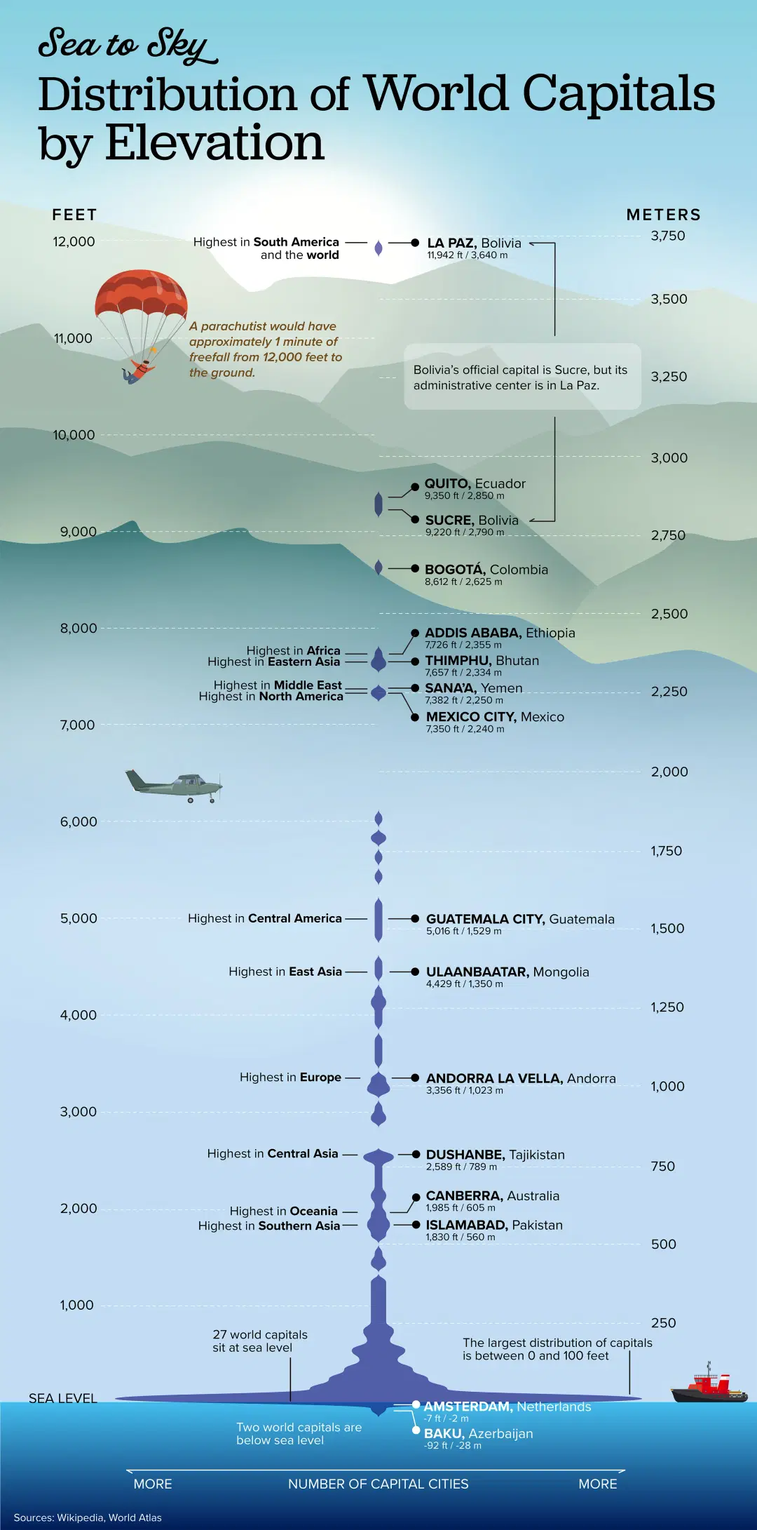
Distribution of World Capitals by Elevation. By our friends at the Visual Capitalis. Try their Voronoi smartphone app.

- From their Voronoi app: https://posts.voronoiapp.com/demographics/Distribution-of-World-Capitals-by-Elevation-1325
- Best visualizations in Voronoi in June: https://www.visualcapitalist.com/best-visualizations-of-june-voronoi-app/
Global Streamflow forecasting
Interesting story about a global streamflow forecasting app.
- ESRI Blog: https://www.esri.com/arcgis-blog/products/arcgis-online/water/improve-global-water-sustainability-with-streamflow-situational-awareness/
- ESRI Streamflow app: https://www.arcgis.com/apps/instant/streamflowviewer/index.html
- Captain Obvious, what’s missing you ask? Some visualization/correlation of the weather events driving the underlying model. https://charts.ecmwf.int/products/medium-mslp-rain?base_time=202407131200&interval=6&projection=opencharts_europe&valid_time=202407131800
GeoTech
AI
AI in GIS.
- Segment Anything Model (SAM) for Geospatial: https://samgeo.gishub.org/
- From ESRI https://www.esri.com/about/newsroom/arcnews/artificial-intelligence-in-gis-promise-progress-and-possibilities/
GPS
A few interesting GPS stories.
- World’s largest GPS drawing. From Massimo on Twitter: https://x.com/rainmaker1973/status/1810646747175076297?s=46&t=Gc0CFq2K263wdxTiNNzIBQ/
- GPS under attack. Jamming, spoofing, age, and lagging technology puts the US world-wide GPS system at risk. https://www.nytimes.com/interactive/2024/07/02/world/gps-threats.html
- What if GPS is knocked out? https://www.nytimes.com/2024/03/28/world/asia/as-threats-in-space-mount-us-lags-in-protecting-key-services.html
Drones
There are a lot of autonomous ocean drones launching out there. A great way to do remote oceanography. Here’s a story about using sail drones to monitor and study hurricanes.
- Sail drones: https://www.bbc.com/future/article/20231026-the-mystery-of-why-hurricanes-suddenly-intensify
Central & South America
Costa Rica
Bananas! Manifest Destiny, Brutality, Railroad Tycoons, Banana Tycons, Slaughter, CIA, and Banana Republics.
This is a really great audio story about the Banana business. Give it a listen.
Brazil / Paraguay
Pantanal
The Pantanal Burns
First world-wide forest fires, now grass fires. The Pantanal a UNESCO World Heritage Biosphere Reserve, the world’s largest freshwater wetland, is burning in Brazil. One big difference. It’s grass, not trees. Grass evolved to be burned. It’s roots survive fires and are a resilient carbon store. When the water returns the fires go out. The ash the fire leaves is now fertilizer.
- The Guardian article about the fires: https://www.theguardian.com/environment/article/2024/jul/09/devastation-as-worlds-biggest-wetland-burns-those-that-cannot-run-dont-stand-a-chance-brazil-pantanal
- Interesting NASA take: https://earthobservatory.nasa.gov/images/149398/a-human-fingerprint-on-the-pantanal-inferno
- About the Pantanal:
- http://www.pantanalnature.com.br/en/pantanal-nature/19/about-the-pantanal
- Nat. Geo. travel: https://www.nationalgeographic.com/travel/article/brazils-best-kept-secret-the-pantanal-wildlife-biodiversity-wetlands
- Wikipedia Pantanal: https://en.wikipedia.org/wiki/Pantanal
- Pantanal Pre-History:
Chile
Wild Life.
A really excellent documentary about Kris and Doug Tompkins and their conservation efforts in Chile, Argentina, and other wild places. https://www.youtube.com/watch?app=desktop&v=yJL-OAPBDa8
US
Economic Geography
Service Deserts
A couple of interesting stories about service deserts. Areas where there are inadequate services (groceries, healthcare, medical) for the local population.
- Impact of Healthcare Deserts on US Military: https://www.npr.org/2024/06/17/g-s1-4187/military-bases-shortage-health-care-troops-army-navy-marines
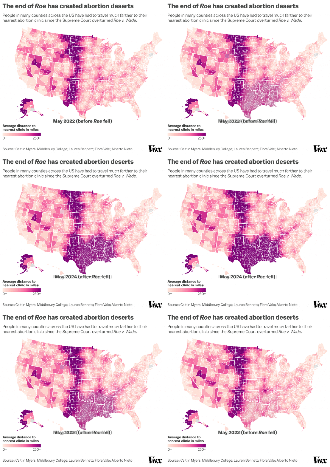
Abortion Deserts:

- Impact of Dobbs over two years. From Vox: https://www.vox.com/explainers/356314/abortion-laws-roe-wade-dobbs-decision-mifepristone-supreme-court
Home Insurance
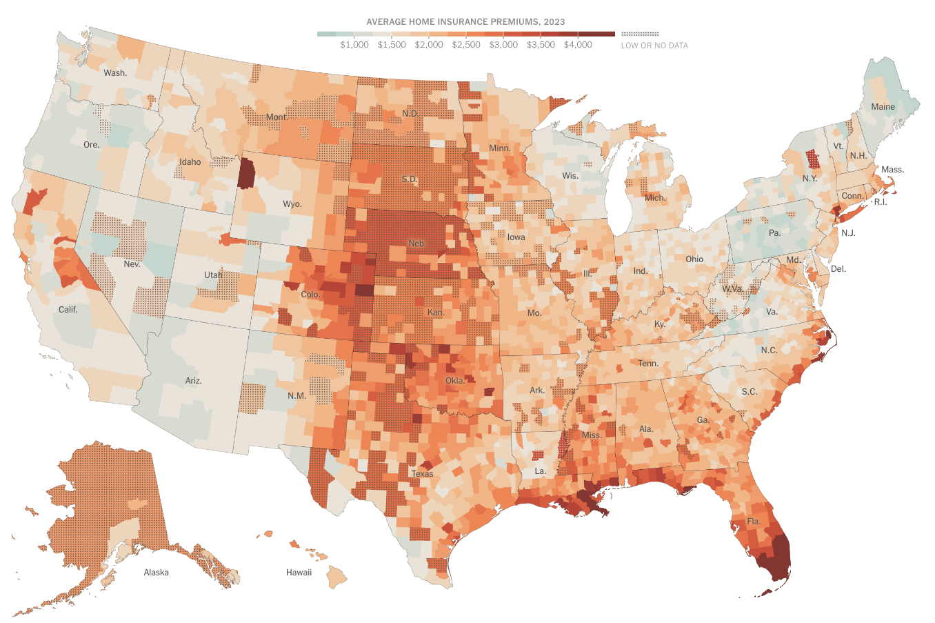
From the NYT - Interesting article about how lax State oversight in setting insurance rates results in much higher insurance premiums. Thanks to State GOP governance. You’re welcome MAGA’s.
Home insurance rates in America Are widly distorted. Climate change is driving rates higher, but not always in areas with the greatest risk.

- US Insurance rates: https://www.nytimes.com/interactive/2024/07/08/climate/home-insurance-climate-change.html
- Interactive map of US Insurance costs: <https://www.nytimes.com/interactive/2024/07/08/climate/home-insurance-cost-county.htm
National Rivers Project
New geodatabase of water trails, whitewater segments, access points, and campgrounds. Great to have it all in one map. Something is still missing though.
- Article from ESRI on NPRD: https://www.esri.com/arcgis-blog/products/national-government/national-government/national-rivers-project-a-recreational-rivers-geospatial-map-database/
- The interactive map. Though I have to say the ESRI tech used is pretty crappy for exploring: http://www.nationalriversproject.com/explorer
- Captain Obvious, what’s missing you ask? Gauge flows. https://waterwatch.usgs.gov/?id=ww_current
Another Whoa Boat
Whoa! This dude is crossing the Atlantic in an unsupported rowboat right now.
- NPR story: https://www.npr.org/2024/07/11/nx-s1-5036545/whales-rower-atlantic-tom-waddington
- Interactive tracker: https://cf.yb.tl/mindoarmatter
LOC maps
It’s always fun to spend time browsing the Library of Congress maps.
This neat panoramic map of Wheeling, West Virginia, shows how the city is built across Wheeling Island & both shores of the Ohio River. It was published in 1870 - check out all the steamships in the river!
Mississippi Freedom Schools Geography Curriculam.
Some lessons for Geographic Education and practice today from the 1960’s Freedom School Geography curriculum.
- From the AAG: https://www.aag.org/revolutionary-geographical-lessons-from-mississippi-freedom-schools/
Demographics
Emigration
American Diaspora.
- Where Americans Emigrate: https://brilliantmaps.com/american-diaspora/
US Religions
“The most religious, and religiously diverse, places in America.”
- From the WAPO: https://www.washingtonpost.com/business/2024/06/28/religious-census-map-diversity-catholics/
Gingko flow
I may have previously mentioned this Oregon Public Broadcasting show but it’s so interesting it deserves a repeat.
- Oregon Field Guide: https://www.opb.org/article/2024/01/13/pacific-northwest-ginkgo-lava-glow-geology-columbia-river-basalt-oregon-agate-beach/
Migration
World’s Largest Antelope Migration - South Sudan
- From The Guardian: https://www.theguardian.com/environment/article/2024/jun/25/south-sudan-antelope-migration-worlds-largest-aoe
Historical Atlas
Super interesting historical Atlas. The Atlas of the Historical Geography of the United States, first published in 1932.
- From the University of Richmond, Digital Scholarship Lab: https://dsl.richmond.edu/historicalatlas/